Hiking in the Hajar mountains: Jebel Shams, Jebel Akhdar and the Balcony Walk
The Hajar mountains of northern Oman offer the country's finest hiking, from October to April. The best-known route is the Balcony Walk (trail W6) on Jebel Shams, about 3 hours there and back along a canyon a kilometre deep; on Jebel Akhdar, you walk among the terraced villages of the Saiq plateau at around 2,000 m. Trails are waymarked but unprotected, and winter nights can be cold.
Checked on 20 October 2026
The Hajar are the great mountain range of northern Oman. Two massifs, about two hours' drive from Muscat, offer most of the hiking: Jebel Shams, the country's highest mountain, and Jebel Akhdar, the "Green Mountain", with its farmed plateau at 2,000 metres. Trails are waymarked with red, white and yellow painted flags and numbered (W4, W6 and so on).
Jebel Shams and the Balcony Walk
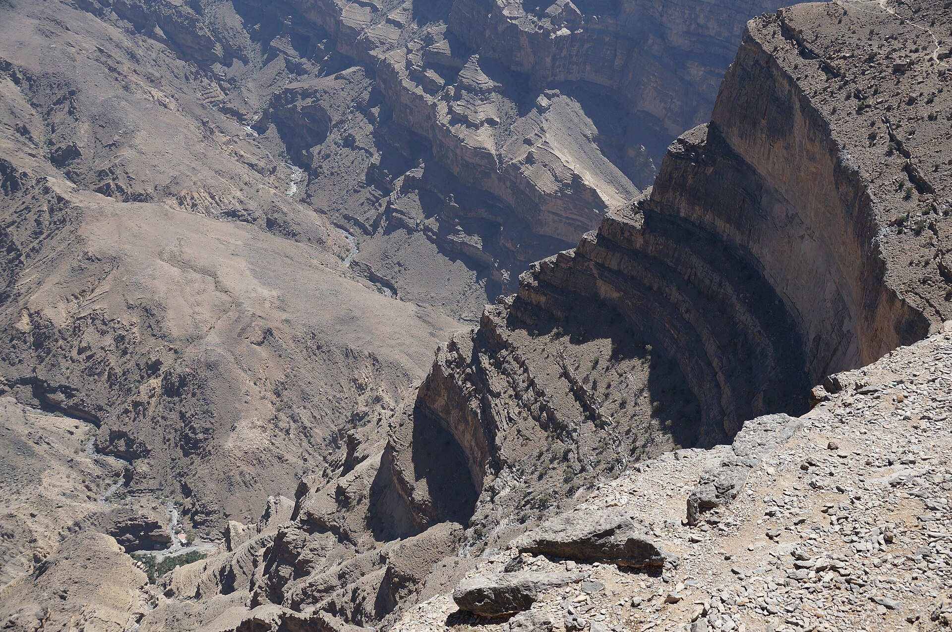
Jebel Shams rises to about 3,000 m: according to Oman's Ministry of Foreign Affairs it is the highest peak on the Arabian Peninsula (Rough Guides gives 3,005 m). It towers over Wadi Nakhr, a gorge often called the "Grand Canyon of Oman".
The Balcony Walk (trail W6)
This is probably the most famous hike in the country. The trail starts from the hamlet of Khateem, a couple of kilometres along a track beyond Jebel Shams Resort, and follows the cliffs halfway up the side of Wadi Nakhr to the abandoned village of As Sab. The cliffs are nearly a kilometre high, the village of Nakhr sits far below, and Egyptian vultures circle overhead.
- Time: about 3 hours there and back.
- Terrain: a cliffside path, with a sheer drop along much of the way.
- Short version: even ten minutes' walk from Khateem gives you the first views.
The south summit (trail W4)
The main summit, topped by a radar dome, is a closed military zone. Trail W4 leads to the south summit, Qarn al Ghamaydah (2,997 m), with views over Wadi Nakhr, Wadi Sahtan and Wadi Bani Awf.
Around Jebel Shams
- Misfat al Abriyeen, at 900 m, is a village of mud and stone houses watered by a falaj (a traditional irrigation channel) more than 2,000 years old.
- Al Hamra, at the foot of the mountain, has an old quarter of mud houses two to four storeys high.
- Via ferrata: a 5-hour guided outing costs from about €134 per person.
Our Jebel Shams page covers places to stay, including Jebel Shams Resort, at the end of the summit road, and The View.
Jebel Akhdar
Jebel Akhdar is a massif of plateaus and gorges whose heart, the Saiq plateau, lies at around 2,000 m (the weather station is at 1,997 m). Walks here lead through terraced fields, orchards and aflaj, the irrigation channels of which five have been UNESCO World Heritage sites since 2006.
- The rose gardens of the terraced villages bloom from late March to early May: see rose season on Jebel Akhdar.
- Via ferrata: a 2-hour guided outing costs from about €100 per person; a 3-hour via ferrata and hike around the village of Sharaijah costs about €115 for a group of up to three.
- Day trip from Muscat: about €117 per person.
The Jebel Akhdar road is closed to ordinary cars: a police checkpoint at the foot of the climb, near Birkat al Mouz, only lets 4WD vehicles through. Our guide to driving in Oman explains the rules. Hotels on the plateau, including Anantara Al Jabal Al Akhdar, Alila Jabal Akhdar and Sahab Resort, are on our Jebel Akhdar page.
Wakan and Balad Sayt, on the Batinah side
On the northern side of the range, facing the Batinah coast, two villages draw hikers:
- Wakan, at up to 2,000 m, which the Ministry of Heritage and Tourism counts among the most beautiful mountain villages in Oman, with old mountain paths now used by hikers all year round;
- Balad Sayt, famous for its farming terraces and the paths that loop around the village; getting there takes a 4WD and experience of mountain driving.
See our Batinah page.
When to go
The season runs from October to April. Readings from the Saiq station give an idea of conditions in the high mountains (highs: 1991-2020 normals; lows and records: readings from 1979 to 1990):
| Month | Average high | Average low | Lowest recorded |
|---|---|---|---|
| November | 18.5 °C | 7°C | -1.2°C |
| December | 16 °C | 5°C | -2.6°C |
| January | 15 °C | 4°C | -3.6°C |
| February | 17 °C | 6°C | -3.0°C |
| March | 20 °C | 9.5°C | 1.4°C |
| April | 24 °C | 13°C | 2.3°C |
In midwinter, bring a warm jacket and layers: there can be frost at night, and Jebel Shams is a thousand metres higher than Saiq. In summer the mountains remain bearable (highs of 27 to 30 °C at Saiq), but the valleys and foothills become scorching: the FCDO (Foreign, Commonwealth & Development Office) notes that extreme heat has caused deaths from dehydration in Oman.
Safety
- Unprotected paths. The Auswärtiges Amt, Germany's foreign office, warns that most mountain and wadi paths have no safety features, and that a small slip in the wrong place can be fatal. It advises going with a tour operator, or at least in a group.
- Stick to marked trails, says the FCDO.
- Altitude. The FCDO also flags a risk of altitude sickness in parts of Oman, notably on Jebel Shams at around 3,000 m.
- Water and phone. For mountain trips, the FCDO recommends carrying a supply of water and a phone, and leaving your plans with someone at home.
- Rain. From October to March, heavy rain can turn a gully into a torrent: keep out of gorges and wadis when heavy rain is forecast. See our guide to wadis, swimming and flash floods.
- Emergency services are on 9999; in remote areas they can take several hours to arrive.
On your own or with a guide
The Balcony Walk is clearly waymarked, and its starting point at Khateem is reached by 4WD. For the south summit, longer routes and the via ferrata, a local guide brings knowledge of the terrain and the day's weather, which is also Germany's advice for any mountain outing.
Read next
Frequently asked questions
How long is the Balcony Walk?
About 3 hours there and back, from Khateem to the abandoned village of As Sab. The trail, W6, is waymarked in red, white and yellow.
Can you climb to the summit of Jebel Shams?
The main summit, at about 3,000 m, is a closed military zone. Trail W4 leads to the south summit, Qarn al Ghamaydah, at 2,997 m.
When is the best time to hike in the Hajar?
October to April. In winter, highs at Saiq are 15 to 17 °C and there can be frost at night, so pack warm clothes.
Do I need a 4WD to hike on Jebel Shams?
Yes, for the last stretch of road, a steep and rocky track. On Jebel Akhdar, a 4WD is compulsory from the police checkpoint at the foot of the climb.
Is hiking in the Hajar dangerous?
Trails are waymarked but unprotected, often along sheer drops. Stay on the route, start early with enough water, go in a group, and avoid gorges on days of heavy rain.
Official sources
- Ministère omanais des Affaires étrangères : géographie d'Oman (accessed 20 October 2026)
- GOV.UK : Oman, safety and security (accessed 20 October 2026)
- GOV.UK : Oman, health (accessed 20 October 2026)
- GOV.UK : Oman travel advice (22/07/2026) (accessed 20 October 2026)
- Auswärtiges Amt : Oman, Reise- und Sicherheitshinweise (04/09/2026) (accessed 20 October 2026)
- NOAA NCEI : normales climatiques de Saiq, 1979-1990 (station 41254) (accessed 20 October 2026)
- Ministère du Patrimoine et du Tourisme, Experience Oman : village de Wakan (accessed 20 October 2026)
- Ministère du Patrimoine et du Tourisme, Experience Oman : village de Balad Sayt (accessed 20 October 2026)
- Oman Observer : accès au Jebel Akhdar en 4x4 (14/02/2022) (accessed 20 October 2026)
- Rough Guides : Jebel Shams, Wadi Nakhr et Balcony Walk (accessed 20 October 2026)
- Wikipedia : Misfat al Abriyeen (accessed 20 October 2026)
- Wikipedia : Al Hamra (accessed 20 October 2026)
- Civitatis : via ferrata du Jebel Shams (accessed 20 October 2026)
- Civitatis : via ferrata du Jebel Akhdar (accessed 20 October 2026)
- Musement : via ferrata et randonnée au Jebel Akhdar (accessed 20 October 2026)
- Musement : journée au Jebel Akhdar au départ de Mascate (accessed 20 October 2026)
A travel advisor replies by email. Free, no commitment.